You can sponsor this page

Variola louti (Fabricius, 1775)

Yellow-edged lyretail
Add your observation in Fish Watcher
Native range | All suitable habitat | Point map | Year 2050
This map was computer-generated and has not yet been reviewed.
Variola louti   AquaMaps   Data sources: GBIF OBIS
Upload your photos and videos
Pictures | Videos | Stamps, coins, misc. | Google image


Tuamotu Islands country information

Common names: [No common name]
Occurrence: native
Salinity: marine
Abundance: | Ref:
Importance: | Ref:
Aquaculture: | Ref:
Regulations: | Ref:
Uses: no uses
Comments: Also Ref. 4787. Museum: Raroia Atoll, CAS 62849.
National Checklist:
Country Information: ttp://en.wikipedia.org/wiki/Tuamotu_Island
National Fisheries Authority:
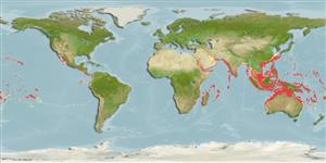
Occurrences: Occurrences Point map
Main Ref: Heemstra, P.C. and J.E. Randall, 1993
National Database:

Common names from other countries

Classification / Names ชื่อสามัญ | ชื่อพ้อง | Catalog of Fishes(สกุล, ชนิด) | ITIS | CoL | WoRMS | Cloffa

> Perciformes/Serranoidei (Groupers) > Epinephelidae (Groupers)
Etymology: Variola: Latin, variolus = pustule, pock (Ref. 45335).

Environment: milieu / climate zone / depth range / distribution range นิเวศวิทยา

Can't connect to MySQL database (fbapp). Errorcode: Too many connections